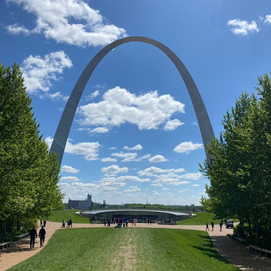
Hello friends!
I was recently in Missouri for a book festival, and someone suggested that if I had time, to consider a visit to the museum beneath the Gateway Arch in St. Louis. They knew I'd like the story of how the arch came to be a monument, for one, but that I’d also appreciate how the museum offers a more inclusive and nuanced story of Westward expansion.
So I went! I've been to the arch twice before, but never to the museum or up the tram to the top of the arch. This time, I learned that while touching the exterior of the arch is permitted, it’s also considered something of a “curse” to do so. Physical contact with the arch means the city of St. Louis will keep pulling you back, thanks to the monument’s boomerang-like shape. And it's true: I've been back to St. Louis twice since I was first there to report on flooding along the Mississippi River in 2017. That's when I touched the arch for the first time; I still haven't made it to the top, alas.
The arch is not a boomerang, though. It's a catenary arch. I don't fully understand the physics holding up the arch—the geometry of it both intrigues and baffles me. But it may be helpful to know that it’s like an upside-down chain turned right-side up, and that the height of the arch is the same as its width from base to base: 630 feet.
Nothing else comes close to it in size, not the Statue of Liberty, not Mt. Rushmore, not the Washington Monument. No public monument of such scale has been constructed in the United States since the completion of the arch in 1965.
Physically and technically, the arch is a monument in a National Park, although the area where it sits in St. Louis was called Jefferson National Expansion Memorial until 2018. When the memorial was proposed by civic leaders in the 1930s, it was envisioned as a commemorative site that would interpret St. Louis’s role in the westward expansion of the United States. Now, the National Park Service calls the arch an "inspirational, transcendent symbol of Thomas Jefferson’s vision of building a unified continental nation" as well as a nod to the city's role "as a confluence and gateway to the American West during the 19th century."
But the shape of the arch itself means nothing, a park ranger told me. The catenary arch was chosen by architect Eero Saarinen because it was a pleasing shape to him as a mid-century architect exploring such forms. (He also designed the Dulles Airport passenger terminal and the iconic Tulip Chair.) The arch is a manifestation of mid-century design aesthetics that appealed to a panel of judges in 1947 for possessing modern, space-age looks.
Planning for the arch began in 1933, when city leaders wanted something as striking for the riverfront in St. Louis as a monument under construction to the Revolutionary War hero George Rogers Clark to the east in Vincennes, Indiana. St. Louis began clearing neighborhoods, tearing down hundreds of buildings and small factories that employed as many as 5,000 people. Plans for a monument went on hold during World War II. Construction finally began in 1963, at the height of the Civil Rights movement; it was met with protest from activists, including Percy Green, who scaled the arch in 1964 to call on trade unions to employ Black workers in its construction.
The revamped museum debuted in 2018, along with a landscape design that more effectively and safely connected the monument to pedestrians in downtown St. Louis. And now, 90 years after a monument was first envisioned on the site, the arch sits adjacent to a downtown district that is all but abandoned, but for the tourists who visit the famous shape along the riverfront.
After I did a handstand against the arch, I drove over the Mississippi River to Illinois to see the Cahokia Mounds, the earthen remnants of the largest pre-Columbian settlement north of Mexico. The city had an estimated population of 10 to 20,000 people at its peak between 1050 and 1150, according to the UNESCO World Heritage Convention. More than 120 earthen mounds elevated the city's population as high as 100 feet above the river plain. Its population may have been bigger than that of London at the same time.
Earlier at the arch, I'd asked a park ranger about the mounds and whether they, too, might be considered monuments. No, she said. They're the remnants of a city. People abandoned the mounds in about 1350 for reasons unknown, but most likely for the same motives that bedevil many fading seats of civilization: war and shifting political allegiances, changing climate, and technological breakthroughs. The ranger likened the mounds to the cliff dwellings at Mesa Verde in Colorado, another park where she has worked—and also an abandoned city.
I climbed the stairs 100 feet up to the top of Monks Mound, the largest of the earthen structures. From there, I could see the St. Louis skyline, nearly 10 miles away. The skyline from afar seemed emblematic of a healthy city, with that elegant arch in the distance. I knew better, having visited St. Louis twice in 2.5 years. Its downtown office district is not just moribund, but nearly dead, firmly rutted in what's known as a "doom loop." My own city's downtown office district has the highest rate of office vacancies in the country. Yet central Portland, for all its problems, thrums with pedestrians and cyclists and thriving businesses, striking in its liveliness compared to central St. Louis.
A recent article in the Wall Street Journal describes how the St. Louis office district has endured "a slow demise for decades" and how it may serve as a warning for other cities facing doom loops, such as San Francisco.
"Population loss, competition from newer offices in the suburbs and failed urban planning left behind a glut of dreary, empty buildings and wide, dangerous roads," the article notes.
What the article didn't mention was how the racist policies of the past, including those that made way for the arch, may have had consequences leading to the modern doom loop in St. Louis. Among them: razing waterfront neighborhoods in the 1930s and eradicating entire Black neighborhoods in the 1950s to make way for interstate highways. St. Louis was the eighth-largest city in the country in 1940 as the monument was planned; it is now the 70th largest. (The shape in this population chart may look familiar.)
Over on the Illinois side of the river, atop Monks Mound, a man asked if I was a local. When I said no, he persisted in asking me to speculate anyway, telling me that his party was trying to determine the identity of a large structure along the Mississippi River to the north of St. Louis.
I had noticed the structure too, and I told him that its size suggested abandoned steelworks or a glass factory, but that I was just guessing. On the trip, I was reading Rinker Buck's Life on the Mississippi, his account of captaining a flatboat from Pittsburgh to New Orleans in 2016. In it, Buck describes many such abandoned factories, foundries and rusted-out forms along America's big rivers.
The Ohio and the Mississippi rivers are "nothing but Superfund sites with water running through them," Buck wrote. (He also writes eloquently about cruising in the flatboat through a cloud of thousands of yellow butterflies, observing that he may not ever again witness something as spectacular in his lifetime. "The immense yellow parade was as populous as an ancient buffalo herd and, as I passed, the butterflies parted to make way for my flagpole and mast.")
From atop the mound, the structure in the distance was so enormous that I thought it, too, could be considered a monument. One that memorializes the industrial past and its lingering presence in our lives and our ecosystems. I did not say this out loud. Not everyone shares my obsession with monuments, and I had a flight to catch.
As I drove back toward St. Louis and through its downtrodden central business district, I thought about how St. Louis was no different than the abandoned mounds across the river. People have always left cities behind, ever since there were cities. A thousand years from now, St. Louis might be viewed as the relic of some former civilization, its still-standing arch a symbol of the fatal geometry of a doom loop.
All the more reason to go to the top, next time I’m in town.
Yours,
Erika
P.S. Apologies for my recent absence from your inboxes. Tax time and tough travel got the best of me this month.
THE NEWS
All the links…
Vote for A Bird With a Knife! Cecilia Brown and Winslow Crane are Friends of The Windfall Dispatch (aka FOTWD) as well as finalists for some serious funding for a documentary they’re making. Your vote could help them land $45,000 to continue with their project this summer.
For Earth Day, I was delighted to do a Q&A about Windfall with The Sunday Stretch, written by another FOTWD, Kelly DiNardo.
What happens after the paint dries? The thought and upkeep behind outdoor public art.
What to do if you encounter a cougar or bear on a trail.
Related: Frontier myth vilified the California grizzly. Science tells a new story.